KUKI-CHIN

DEFINITION OF KUKI FLAG

KUKI POLITICAL FLAG

KHULMI KUKI CHIN MIZO
ADJACENT COUNTRY

KUKI JALEN GAM
KHULMI KUKI AFFRIDIS

POLITICAL COUNTRY IN INDO -PAKISTAN AND INDO- AFGHANISTAN
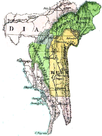
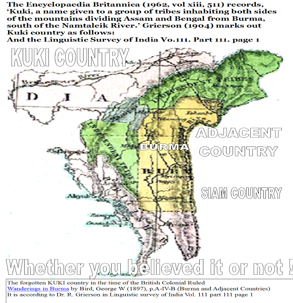
THE TERITORY OF THE KUKULAND BY DR.GRIERSON
Kuki Country (Grierson, GA (1904) Linguistic Survey of India, Vol 111, Part 111)
The Encyclopaedia Britannica (1962, vol xiii, 511) records, ‘Kuki, a name given to a group of tribes inhabiting both sides of the mountains dividing Assam and Bengal from Burma, south of the Namtaleik River.’ Grierson (1904) marks out Kuki country as follows:The territory inhabited by the Kuki tribes extends from the Naga Hills in the north down into the Sandoway District of Burma in the south; from Myittha River in the east, almost to the Bay of Bengal in the west. It is almost entirely filled up by hills and mountain ridges, separated by deep valleys. A great chain of mountains suddenly rises from the plains of Eastern Bengal, about 220 miles north of Calcutta, and stretches eastward in a broadening mass of spurs and ridges, called successively the Garo, Khasia, and Naga Hills. The elevation of the highest point increases towards the east, from about 3,000 feet in the Garo Hills to 8,000 and 9,000 in the region of Manipur. This chain merges, in the east, into the spurs, which the Himalayas shoot out from the north of Assam towards the south. From here a great mass of mountain ridges starts southwards, enclosing the alluvial valley of Manipur, and thence spreads out westwards to the south of Sylhet. It then runs almost due north and south, with cross-ridges of smaller elevation, through the districts known as the Chin Hills, the Lushai Hills, Hill Tipperah, and the Chittagong Hill Tracts. Farther south the mountainous region continues, through the Arakan Hill tracts, and the Arakan Yoma, until it finally sinks into the sea at Cape Negrais, the total length of the range being some seven hundred miles. The greatest elevation is found to the north of Manipur. Thence it gradually diminishes towards the south. Where the ridge enters the north of Arakan it again rises, with summit upwards of 8,000 feet high, and here a mass of spurs is thrown off in all directions. Towards the south the western off-shoots diminish in length, leaving a track of alluvial land between them and the sea, while in the north the eastern off-shoots of the Arakan Yoma run down to the banks of the Irawaddy. This vast mountainous region, from the Jaintia and Naga Hills in the north, is the home of the Kuki tribes. We find them, besides, in the valley of Manipur, and, in small settlements, in the Cachar Plains and Sylhet.
 | Gmail - INDIA CONSTITUTIONS IN KHULMI MANMASI TRIBES - ukexim@gmail.com.htm 203K Open as a Google document View Download
|
Wednesday, September 30, 2015
Tuesday, May 11, 2010
Monday, May 10, 2010
KUKI HISTORY IN 18 CENTURY
SHIH HUANGTI AND KHULMI KUKI.htm
3K View Download
The North-East Frontier of India - Google Books Result
HILL TIPPERAH. Having now completed the survey of the tribes dwelling ... from Cachar on the north to Chittagong on the south— impinging on the east on the ...
books.google.co.in/books?id=E_
The North-East Frontier of India - Google Books Result
RHETORIC OF KUKI NATIONALISM
Rhetorics of Kuki Nationalism
The people's ancestral lands are within Northeast India, Northwest Myanmar and the .... 'The year 1860 saw the great Kuki invasion of Tipperah [Tripura], ... Calcutta 31 Mackenzie, A, The North-East Frontier of Bengal, (2005, ... of the Government with the Hill Tribes of the North-East Frontier of Bengal)), ...
www.scribd.com/doc/27825095/Rhetorics-of-Kuki-Nationalism - Cached
www.scribd.com/doc/27825095/
Sunday, May 9, 2010
THE KUKI REBELLION 1917-1919
ZOU GAAL: ZOU REBELLION (1917-1919 AD)
Kum 1772-1774 lai in mualmite[hill people] Burma apat in Lushei hills ah na pem lut .... in present-day Northeast India, Northwest Burma and the Chittagong hill tracts in Bangladesh. .... 'The year 1860 saw the great Kuki invasion of Tipperah [Tripura], ..... Mackenzie, A, The North-East Frontier of Bengal, (2005, ...
zougaal.blogspot.com/2008_09_17_archive
zougaal.blogspot.com/2008_09_
KUKI SURVEYED LAND
RESTRICTED THE NORTHERN BORDER SINO-INDIAN BOUNDARY India's ...
- 6:56amFile Format: PDF/Adobe Acrobat - Quick View
India's northern border stretches from the north-western tip of the State of Jammu and Kashmir ..... Arunachal Pradesh earlier known as North East Frontier ...
www.bharat-rakshak.com/LAND-FORCES/.../1962Chapter01.pdf - Similar
India's northern border stretches from the north-western tip of the State of Jammu and Kashmir ..... Arunachal Pradesh earlier known as North East Frontier ...
www.bharat-rakshak.com/LAND-
Subscribe to:
Posts (Atom)

